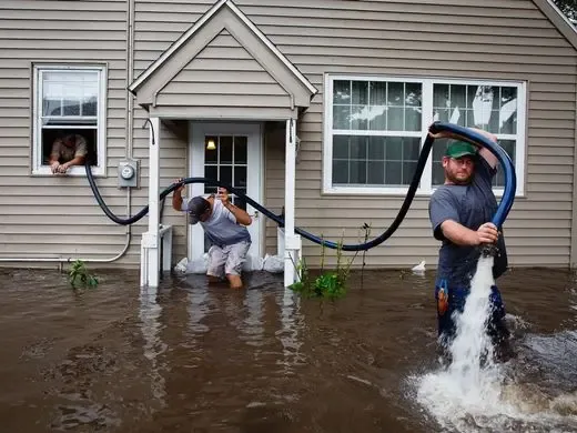
The central core of Morrisville lies along the upper part of Crabtree Creek, which feeds Lake Crabtree in the southeastern part of town. The National Weather Service tracks the creek with a gauge at the Crabtree Creek Greenway, and its stage numbers say in plain terms what the water is doing.
Key takeaways
- At 9 feet the gauge lists minor flooding, when the Crabtree Creek Greenway floods.
- At 10 feet it lists extensive flooding of the athletic fields between the Greenway and Aviation Parkway.
- At 13 feet it lists creek water reaching Aviation Parkway and adjacent residential buildings.
- The preliminary crest of 11.12 feet on August 8, 2024 sat between the 10 and 13 foot stages.
- Creek water that enters a building is flood water, handled as Category 3 from the first step.
What the gauge on Crabtree Creek measures
A stage is the height of the creek at the gauge, measured in feet. The National Weather Service attaches a plain description to each stage, so a number tells a story.
Crabtree Creek is a tributary of the Neuse River. The three stages below come from the gauge at the Crabtree Creek Greenway in Morrisville.
Creek stage depends on rain that falls upstream as well as rain overhead, so the gauge can keep climbing after the sky has cleared. That is why the number is worth watching, not just the weather.
- 9 feet: minor flooding, when the Crabtree Creek Greenway floods.
- 10 feet: extensive flooding of the athletic fields between the Crabtree Creek Greenway and Aviation Parkway.
- 13 feet: water from Crabtree Creek reaching Aviation Parkway and adjacent residential buildings.
Recent crests in perspective
The gauge has recorded four preliminary crests in recent years. Every one of them sits between the minor flooding stage and the stage at which water reaches buildings beside the creek.
Crests are listed as preliminary because the numbers can still be revised later. They still give a fair sense of how high the creek has climbed in the past few years.
Two of the four crests came about a month apart in the fall of 2021, which shows that a high creek can return before a space has fully dried.
- August 8, 2024: 11.12 feet.
- October 9, 2021: 10.73 feet.
- September 9, 2021: 10.4 feet.
- July 9, 2023: 9.12 feet.
What those numbers do and do not say
None of the four crests reached 13 feet, the stage at which the gauge lists water reaching adjacent residential buildings. That is useful context, but a stage number describes the creek, not any single building.
The Town of Morrisville's stormwater page explains the Special Flood Hazard Area and says Morrisville can have, and has had, more than one 1 percent annual chance flood in a given year. A name like that describes a probability, not a schedule.
- A stage is a reading at one spot on the creek.
- Buildings sit at different heights, so a stage means different things at different addresses.
- Rain upstream can raise the creek after the sky clears.
- A crest that stays below 13 feet still floods the Greenway and the athletic fields.
Flood controls on the creek
Wake County runs ten flood control structures in the Crabtree Creek watershed that the federal government built in the 1970s and 1980s, including Lake Crabtree and Brier Creek Reservoir.
Lake Crabtree got a real time water level monitoring system in 2024, and Wake County planned to add nine more flood control sites in summer 2025 with the U.S. Geological Survey.
The Town also keeps watershed assessment reports for Kit Creek and the Neuse River Basin, and the Hatcher Creek and Indian Creek greenways run through town.
- Flood control structures slow water, but they do not remove the chance of a high creek.
- Real time readings let people watch the water instead of guessing.
- Cleanup begins only after water has stopped rising and it is safe to enter.
- Public monitoring gives owners advance notice, and the cleanup crew gives them a plan once the water has passed.
When creek water enters a building
Water that comes in from a creek is flood water. It carries soil, debris and whatever else it passed on its way, which is why the restoration industry treats it as Category 3.
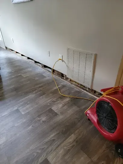
A storm and flood water cleanup call starts the removal of soaked carpet, pad and low drywall. Hard, sealed surfaces are cleaned and dried.
The sooner removal starts, the less water soaks into framing. Materials left wet for days can swell, stain and hold bacteria.
- Stay out of any room with standing water until the power is off.
- Do not walk through creek water to reach equipment or stored items.
- Photograph the high water mark on walls and doors.
- Keep children and pets away from areas the water reached.
Usually removed
- Carpet and pad that sat in the water.
- Drywall and insulation that wicked water up the wall.
- Soft trim, baseboards and particleboard cabinets that swelled.
Usually cleaned and dried
- Concrete slabs and sealed tile.
- Wall studs, plates and joists.
- Solid wood furniture that is not warped.
Extraction and drying after creek water
Once the creek drops, the water inside has to come out. A water extraction crew pulls standing water from floors and low spots, and then the team maps what the water reached.
Drying follows with fans and dehumidifiers. Readings on framing and concrete show when the space has reached the dry goal through structural drying.
The main storm and flood water cleanup service covers the full job from removal to the dry goal.
- Standing water is removed first.
- Soaked materials come out next, before they hold moisture against framing.
- Fans and dehumidifiers run, and readings repeat until the framing is dry.
Parks, trails and lakes along the creek
These public spaces sit along the same water system that the gauge reads. A trail that floods is often the first visible sign that the creek is rising.
Each park also gives a landmark for talking about the creek. Knowing which stage floods which path gives residents a clearer picture of what is happening upstream.
- Crabtree Creek Nature Park, a wooded and wetland park.
- The Hatcher Creek greenway at Morrisville Community Park.
- Lake Crabtree County Park, with boating, trails and picnic shelters.
- The Indian Creek Greenway and Trailhead.
Questions
What does a 9 foot stage on Crabtree Creek mean?
The National Weather Service gauge lists minor flooding at 9 feet, when the Crabtree Creek Greenway floods.
What happens at 13 feet?
The gauge lists water from Crabtree Creek reaching Aviation Parkway and adjacent residential buildings.
What was the highest recent crest on the creek?
The gauge recorded a preliminary crest of 11.12 feet on August 8, 2024.
Is creek water treated differently from a pipe leak?
Yes. Creek water is Category 3 flood water, so porous materials it touched are usually removed rather than dried.
Does a stage number mean a building will flood?
No. A stage describes the creek at the gauge. It helps people watch the water, but it does not predict what any one building will see.